
A section of Geography
This page is one small part of Good Sites for Kids!
![]() Follow us on Facebook
Follow us on Facebook
![]()
40 maps that explain the Roman Empire from Vox "Two thousand years ago, on August 19, 14 AD, Caesar Augustus died. He was Rome's first emperor, having won a civil war more than 40 years earlier that transformed the dysfunctional Roman Republic into an empire. Under Augustus and his successors, the empire experienced 200 years of relative peace and prosperity. Here are 40 maps that explain the Roman Empire — its rise and fall, its culture and economy, and how it laid the foundations of the modern world." Vox's excellent choice of maps and trivia graphics explain everything about the Empire. CAUTION - Item # 19 is inappropriate for under 18. R-rated ancient painting (one of the milder ones from Pompeii). Commentary R-rated also. If you're a parent or a teacher, you will probably want to leave # 19 out. Romans generally saw these as harmless religious or fertility symbols. We generally see them as not worth unemployment.
40 maps that explain World War I from Vox (Written in August 2014) "One hundred years ago today, on August 4, 1914, German troops began pouring over the border into Belgium, starting the first major battle of World War I. The Great War killed 10 million people, redrew the map of Europe, and marked the rise of the United States as a global power. Here are 40 maps that explain the conflict — why it started, how the Allies won, and why the world has never been the same." Vox's excellent choice of maps and trivia graphics explain everything about WW I. This is an amazing history resource!
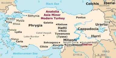
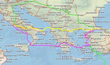
Ancient Anatolia and modern
Turkey occupy the
same space on Earth. Here's a reference map of
the ancient cities, kingdoms, and archaeological
sites inside the area, inside the borders of modern
Turkey. Learn more about the many peoples and
complicated ancient history of this region at
Wikipedia and Pinterest.
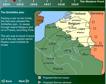 Animated
Map: The Western Front, 1914 - 1918 This BBC Flash slideshow briefly explains
everything major that happened on the Western Front, 1914-1918, including the
offensives.
Animated
Map: The Western Front, 1914 - 1918 This BBC Flash slideshow briefly explains
everything major that happened on the Western Front, 1914-1918, including the
offensives.
Animated map of what Earth would look like if all the ice melted "We learned last year that many of the effects of climate change are irreversible. Sea levels have been rising at a greater rate year after year, and the Intergovernmental Panel on Climate Change estimates they could rise by another meter or more by the end of this century. As National Geographic showed us in 2013, sea levels would rise by 216 feet if all the land ice on the planet were to melt. This would dramatically reshape the continents and drown many of the world's major cities." Note: 216 feet is about 66 meters (65.8). Also, the rate of melting may vary over time. Could it all melt? It has, at times in the far past. Draw your own conclusions.
Atlapedia Like an online almanac, with country info and stats, political and regional maps, and downloadable maps.
 This
animated gif map shows the "Modern
political history of the Balkans from 1800 onwards" to now. The full-sized
version is a great visual aid for explaining why the Balkans got to be the mess
they were for most of modern history. WW I and WW II are shown also. It's from
Wikipedia.
This
animated gif map shows the "Modern
political history of the Balkans from 1800 onwards" to now. The full-sized
version is a great visual aid for explaining why the Balkans got to be the mess
they were for most of modern history. WW I and WW II are shown also. It's from
Wikipedia.
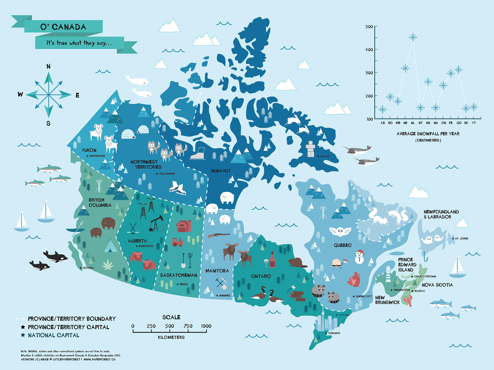 Map
of Canada by littlepaperforest on deviantart. Charming, whimsical, and BIG
(1600x1200) map. All the provinces and capitals are shown, also what each province
is known for. This is all over Pinterest, too, but the original's on deviantart.
Going in Geography and Maps.
Map
of Canada by littlepaperforest on deviantart. Charming, whimsical, and BIG
(1600x1200) map. All the provinces and capitals are shown, also what each province
is known for. This is all over Pinterest, too, but the original's on deviantart.
Going in Geography and Maps.
Cartography resources Huge list of map links.
Digital Map of the Roman Empire

HUGE map lets you zoom way in and way out! See the network of road, the names and borders of the provinces, zoom in on the smallest village mentioned in history, and the tiniest island. See where towns and forts were (modern place names in italics help).
![]()
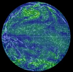 Earth
Wind Map Quoting Daily
Kos: " ... a new graphical development called the Earth Wind Map has
set a new standard for combining fascinating imagery with (near) real-time wind
information. Check it out and we think you'll agree that the 'wow' factor is
off the chart.
Earth
Wind Map Quoting Daily
Kos: " ... a new graphical development called the Earth Wind Map has
set a new standard for combining fascinating imagery with (near) real-time wind
information. Check it out and we think you'll agree that the 'wow' factor is
off the chart.
The interactive map allows users to monitor wind patterns virtually anywhere on earth. The Google Earth-style display lets you adjust the globe's image to pinpoint any spot on the planet. Data is updated every three hours.
While flow patterns indicate wind direction — almost hypnotically — all over the planet, a subtle color scheme indicates wind strength, with gentle breezes represented by thin green lines, stronger winds by bright yellow, and extreme winds by red."
Finding Points on a Globe from KidsGeo is the first of four consecutive pages that explain Latitude, Longitude, and GPS, in terms of a Cartesian grid on a globe. Well illustrated, and each page builds on the previous ones. Click Next and Previous at the bottom of each page to move around.
Gall-Peters vs Mercator Two different projections of the world map.
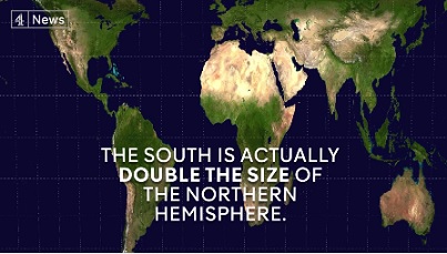
One is much more accurate comparing sizes of islands and continents; the other is traditional, comfortable, and exaggerates the size of the northern (or "white") countries. Watch the video, then research this for your own edification.
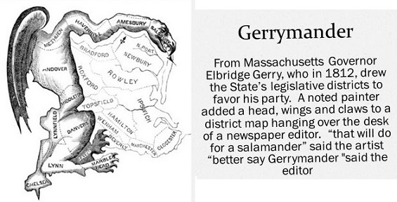
![]() What
Is Gerrymandering? A short video explains what's wrong with this ugly political
practice. Watching it gives learners the needed background to appreciate the
importance of fighting gerrymandering with geometry!
What
Is Gerrymandering? A short video explains what's wrong with this ugly political
practice. Watching it gives learners the needed background to appreciate the
importance of fighting gerrymandering with geometry!
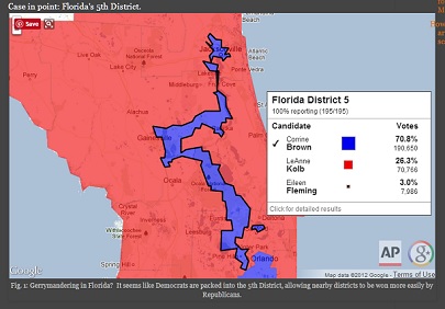
Meet the Math Professor Who’s Fighting Gerrymandering With Geometry This link's from A Mighty Girl's Facebook site. The original article from The Chronicle of Higher Education explains it in a more academic. Basically, Professor Moon Duchin of Tufts University, "has helped create a program to train mathematicians to serve as expert witnesses in court cases over redrawn electoral districts." Since courts all the way up to the US Supreme Court have problems understanding gerrymandering, this is a good plan to overcome this evil practice. Read one or both articles, and learn.

GIS Resources "Resource for GIS ica, sans-serif">Welcome to the World of Global Information Systems" Lots of valuable links to maps sites, GIS lesson plans & education sites, geography links, and much more! Along with its sister GPS site, this is part of an Illinois-based ed initiative.
GPS Resources "Welcome to the World of Global Positioning Systems. The following links will hopefully give the participants a resource to obtain information about GPS, sources to companies related to GPS, projects that are using GPS, and educational sites that have a wealth of information." A wealth of information about, and links to, GPS lesson plans and activities, Geocaching activities, the Travel Bug project, more. Along with its sister GIS site, this is part of an Illinois-based ed initiative.
Geoguessr "Embark on a journey that takes you all over the world. From the most desolate roads in Australia to the busy, bustling streets of New York City." May be too hard for middle schoolers unless they do it in groups. Teachers could walk younger students through the game by asking questions of the class and giving hints. It's a game to see if you can figure where you are, using Google Street View. All you know at the start is that you are somewhere on Earth. If that's too much area for you, there are maps of cities (New York City, London, Paris, etc.) and of countries (Canada, Australia, UK, Netherlands, etc.) and the European Union! Be a detective and a geographer. It's fun to use clues such as traffic signs, language, architecture, climate, trees, crops, and anything else you can find. ("Hmm. Olive trees and palm trees. That sign looks like it's in Spanish.") You could look up names of towns. ("I wonder what country Poznan is in?") Talk about honing skills! Try it out!
Lat-Long.com "Search More Than 2 million U.S. Locations in an Instant! Search More than 2 Million Places: Parks, cemeteries, bridges and post offices. Find these and more on Lat-Long.com."This site is a list of all 50 US states. You can click on a state and check out its features by category (did you know South Dakota has 91 canals?) or you can search by item and a state pulldown menu from the main page (example: glaciers in Alaska.) Google Maps display each item. Latitudes and longitudes are given in tradish degrees, minutes, and seconds; also in decimal degrees.
Latitude and Longitude Explains these terms and how they work.
Map Stack by Stamen. “Map Stack is about putting your creativity on the map, making it radically simpler to design your own map styles, without having to know any code, sign up for anything, install any software, or do any typing.” (from Good.is) Assemble a selection of different map layers like backgrounds, satellite imagery, terrain, roads or labels! Tweak Photoshop-like controls like colors, masks, opacity and brightness to make a map your own! Share your map with a link or Pinterest or Tumblr!
Maps Home Page Helps kids learn about mapping.
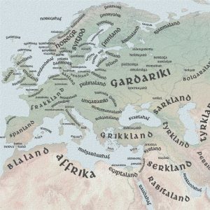
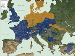
"This vast map covers just about all possible tribes that
were documented in the first centuries BC and AD, mostly
by the Romans and Greeks. Some migration was involved during this time, and
some tribal divisions too, so there
may be a few instances in which names are repeated." Click on the small
map at this site, and it becomes a humongous giant map
with links for most of the tribes. "Click anywhere on the map to load the
full size map with links to individual tribes.
German tribes are in orange, Celtic tribes are in blue, Irish and Picts in green.
Tribes who don't fit in those have no color and no links.
"Warning: the full size map is a very large image. It may take some time
to load over slower connections.)"
Maps4Kids "Data is available on every State in the US, as well as for every Country in the world ! Maps4Kids.com is a great resource for fast facts about places in our world. The Top 10 page shows you the highest, longest, most populous."
Mathematics of Cartography Don't be scared away by the title - it's a very good discussion of maps. Part of Cynthia Lanius's huge math web.
 with an interactive map.") Medieval
Map
"This website illustrates the historical changes that occurred in the Medieval
Era (400 - 1500) with an interactive map." Understatement! Move back and
forth through time in 10 to 50 year intervals. Click on one button to show cities,
another to show decisive battles. Click the ? button to see a modern map. For
battles, there is a brief synopsis in a popup window, with the option to go
to Wikipedia. Clicking on a city icon sends you directly to Wikipedia. The map
shows all the contemporary peoples and states for the period you choose. Clicking
on any label (example: "Balts") brings up a three-section pie graph.
One section - the "W", sends you to Wikipedia. Clicking the folder"
icon opens up a book or article, if there is one (in this case an e-book called
"The Balts", by Marija Gimbutas). Clicking on the "film"
icon will open a video, if there is one. The site is constantly being improved.
It's quite a trip through time for middle school and older. Visual learners
may finally grasp the idea of huge groups of peoples moving across Europe. See
empires and kingdoms rise and disappear. Wonder at names like the Umayyads,
the White Sheep Turks, the Principality of Polotsk, Navarre, Swabia, Trebizond,
and all the rest.
Medieval
Map
"This website illustrates the historical changes that occurred in the Medieval
Era (400 - 1500) with an interactive map." Understatement! Move back and
forth through time in 10 to 50 year intervals. Click on one button to show cities,
another to show decisive battles. Click the ? button to see a modern map. For
battles, there is a brief synopsis in a popup window, with the option to go
to Wikipedia. Clicking on a city icon sends you directly to Wikipedia. The map
shows all the contemporary peoples and states for the period you choose. Clicking
on any label (example: "Balts") brings up a three-section pie graph.
One section - the "W", sends you to Wikipedia. Clicking the folder"
icon opens up a book or article, if there is one (in this case an e-book called
"The Balts", by Marija Gimbutas). Clicking on the "film"
icon will open a video, if there is one. The site is constantly being improved.
It's quite a trip through time for middle school and older. Visual learners
may finally grasp the idea of huge groups of peoples moving across Europe. See
empires and kingdoms rise and disappear. Wonder at names like the Umayyads,
the White Sheep Turks, the Principality of Polotsk, Navarre, Swabia, Trebizond,
and all the rest.
Navigation Education Materials Ten middle school science lesson plans ready to go! These teach navigation, mapping, topo maps, GPS, and space navigation! Excellent introduction to a technical subject. From the renowned Institute of Navigation. Because we need to educate kids in important technical subjects.
 ORBIS The Stanford Geospatial Network
Model of the Roman World. This is not your normal map! "ORBIS allows us
to express Roman communication costs in terms of both time and expense. By simulating
movement along the principal routes of the Roman road network, the main navigable
rivers, and hundreds of sea routes in the Mediterranean, Black Sea and coastal
Atlantic, this interactive model reconstructs the duration and financial cost
of travel in antiquity." Short version: Travel the rivers, roads, and seas
of the Empire! Find out how long it took and how much it cost. Lots of ways
to get from point A to point X, depends on who you are and how much money and
time you have. There's a menu bar along the top. Click Using
ORBIS to watch a tutorial (it's good, we recommend it). Click the Adobe
Acrobat Reader symbol at the the top right corner of the page to get the tutorial,
lesson ideas, and explanations in .pdf form. Clever teachers could adapt this
for any level from upper elementary up to college-level. It's that good. Different
in purpose from the excellent Digital
Map of the Roman Empire, but both are quite detailed.
ORBIS The Stanford Geospatial Network
Model of the Roman World. This is not your normal map! "ORBIS allows us
to express Roman communication costs in terms of both time and expense. By simulating
movement along the principal routes of the Roman road network, the main navigable
rivers, and hundreds of sea routes in the Mediterranean, Black Sea and coastal
Atlantic, this interactive model reconstructs the duration and financial cost
of travel in antiquity." Short version: Travel the rivers, roads, and seas
of the Empire! Find out how long it took and how much it cost. Lots of ways
to get from point A to point X, depends on who you are and how much money and
time you have. There's a menu bar along the top. Click Using
ORBIS to watch a tutorial (it's good, we recommend it). Click the Adobe
Acrobat Reader symbol at the the top right corner of the page to get the tutorial,
lesson ideas, and explanations in .pdf form. Clever teachers could adapt this
for any level from upper elementary up to college-level. It's that good. Different
in purpose from the excellent Digital
Map of the Roman Empire, but both are quite detailed.
 Old
Norse Map of the Viking World "The geographical range of Viking exploration
between the 9th and 12th centuries AD was amazing. From their Northern European
homelands in today’s Norway, Denmark and Sweden they used the Norwegian
and Baltic Seas to engage with the world as looters, traders, colonists and
mercenaries." Clicking on the map enlarges it - you could go from the 768
X 364 size up to a 5039 X 2413 monster with several intermediate sizes, if you
wanted. All the placenames are in Old Norse. The map also comes in modern English,
as a guide.
Old
Norse Map of the Viking World "The geographical range of Viking exploration
between the 9th and 12th centuries AD was amazing. From their Northern European
homelands in today’s Norway, Denmark and Sweden they used the Norwegian
and Baltic Seas to engage with the world as looters, traders, colonists and
mercenaries." Clicking on the map enlarges it - you could go from the 768
X 364 size up to a 5039 X 2413 monster with several intermediate sizes, if you
wanted. All the placenames are in Old Norse. The map also comes in modern English,
as a guide.
Reading a Map A kids' site from WebRangers, National Park Service (NPS), US Department of the Interior. This interactive video walks kids through map reading. It introduces topography - depictions of hill, streams, trails, etc. , what hilltops, slopes, and flat land look like on a "topo" map. Goes over parts of a map; legend, scale, and direction indicator or compass rose. Following trails on a map is covered. This elementary activity does not cover, saddles, canyons, or passes; but it does lay a foundation for further learning. There are also links to more about maps, a Teachers' Resource Guide, and links to many other WebRangers activities.
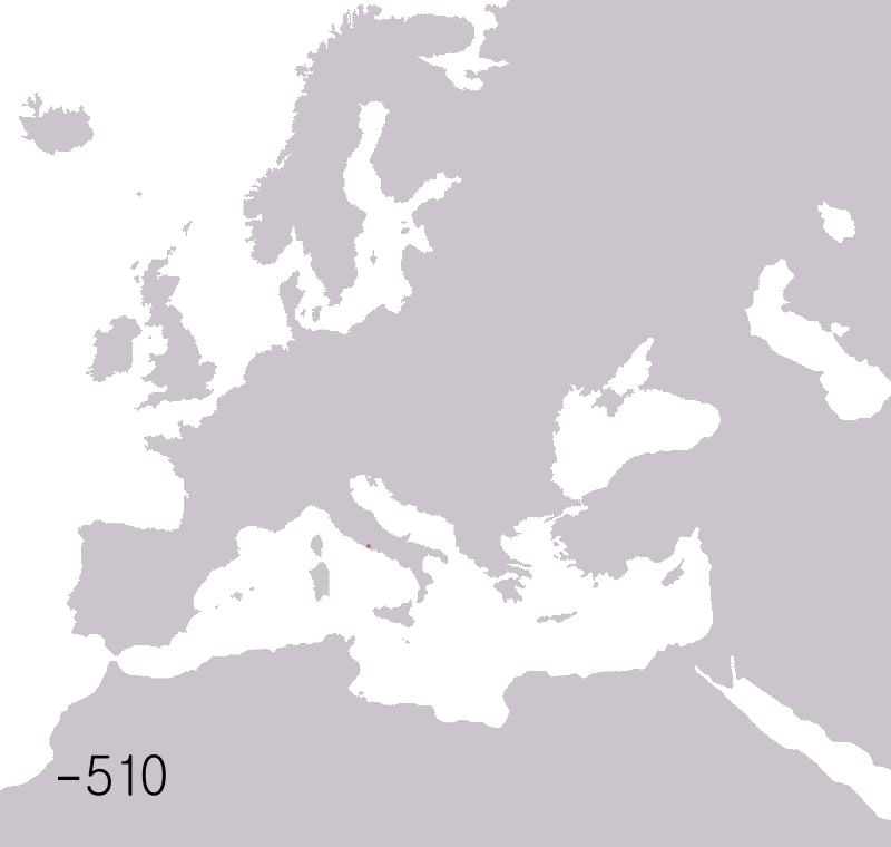
Roman Empire Animated Map covers expansions and contractions of the Empire from 510 BC to 1453 AD. Animated .gif file would be good for ancient history classes.
![]() Seterra
- Learn Geography. "Seterra is a challenging educational
geography program with more than 70 different exercises. Learn about states,
provinces, countries, capitals, flags and cities in Africa, Europe, South America,
North America, Asia and Australia, using outline map exercises!"
Quick, what's the capital of Slovenia? Of
Texas? Where is Uppland? Tasmania? Find Burkina Faso! Find West Virginia! Click
on Fujian Province! This is wonderful freeware
that really works with kids ages 9 and up - we've used it! Great for high school
and college geography, too. From the talented lady in Sweden who brought you
Sebran!
Good
news, everyone! Seterra version 4 can be played online OR downloaded and installed, and
micro-countries are included! Used and loved by geography teachers,
it's one of our faves!
Seterra
- Learn Geography. "Seterra is a challenging educational
geography program with more than 70 different exercises. Learn about states,
provinces, countries, capitals, flags and cities in Africa, Europe, South America,
North America, Asia and Australia, using outline map exercises!"
Quick, what's the capital of Slovenia? Of
Texas? Where is Uppland? Tasmania? Find Burkina Faso! Find West Virginia! Click
on Fujian Province! This is wonderful freeware
that really works with kids ages 9 and up - we've used it! Great for high school
and college geography, too. From the talented lady in Sweden who brought you
Sebran!
Good
news, everyone! Seterra version 4 can be played online OR downloaded and installed, and
micro-countries are included! Used and loved by geography teachers,
it's one of our faves!
 TimeMaps
specialise in map-based history timelines.
TimeMaps
specialise in map-based history timelines.
TimeMaps' FREE interactive World History
Atlas is the most comprehensive history atlas on the internet. Inside you
will find over 1,500 maps, well-written historical overviews, depth-articles,
images and much more.
Maps and timelines (timemaps) of every civilization, nation and empire. See
the geographical context, chronology, connections and big pictures of history.
FREE!" Fabulous interactive maps that branch
off fractally, let students explore everything about the history of any part
of the world from 3500 BC (5500 BP) to the present day. A short video
shows some examples. The Atlas
shows relationships between peoples and civilizations using graphics and text.
It's full of information. There are also very good and inexpensive iPad, iTunes,
and Chrome apps for sale, from $1 to $3 that we saw, and at least one (The Black
Death) for £1.99. Are the apps worth it! In a word, yes! Our historian
was nearly drooling. They also have available various teaching resources and
materials.
Popular Topics Click & grab the big orange button, then slide the
big orange button to see 13 interactive history timelines for different parts
of the world.
This site is everything it claims to be! Enough! Go see it for yourself!
Watch the United States Grow This animated gif created by redditor Anthony Vincent (we can't show his reddit name on a kid site), lets you watch the expansion of the USA from 1789 to 1959 (question for students - Why 1959?). States, territories becoming states, treaty effects, the Mexican and Civil Wars, the California and Texas Republics joining as states, and the conquest of the Kingdom of Hawaii are all here.* You'd better not blink - this is VERY fast. Perhaps teachers could assign groups of student to watch different sections of North America? * Missing are American Samoa, Guam USA, Puerto Rico USA, the Virgin Islands USA, and small atolls & rocks in the Pacific. Can't have everything!
What's my latitude and longitude? Go to this site and it will show you your latitude and longitude, based on your IP address. This could be useful as an introduction/attention step for a lesson on lat & long. Credit to David Stoline and reddit.
You Really Can’t Imagine How Deep The Ocean Is This page makes a good effort to instill a sense of how deep the ocean is. The ocean is seriously deep! The AVERAGE depth of the ocean is 4,267 meters. The deepest part we know of so far is almost 11,000 meters (11 km). To see only the video portion, click here The Ocean is Way Deeper Than You Think. It's good, even though the narrator is forced to talk fast to keep up with this 6:52 video! To see a much shorter (1:24) CGI video of a sperm whale fighting a colossal giant squid, click here to watch COLOSSAL SQUID Vs. SPERM WHALE
![]() to top of page
to top of page ![]()
![]() to Good Sites
to Good Sites
Maybe a map can help me find that bone!
Powered
by ![]() The World's #1 Web Host
The World's #1 Web Host