
Weather Sites
![]() Follow us on Facebook
Follow us on Facebook
![]()
This page is one small part of Good Sites for Kids!
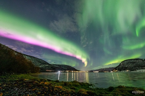
Aurora over
Finnish Lapland New Years Eve
Original size = 2048x1365 pixels
Posted on reddit by Eddynstain

A crack in the Earth's magnetic field over the weekend
(not uncommon around the Equinox) allowed the Solar Wind to
pour in over Norway. The result? A fantastic display of the
Northern Lights, that look like it's almost flowing to the ground!
Very cool. (spaceweather.com) This image is from
Greenlander Tromsø. Check them out...great stuff!
Credit = Tony Pann, Meteorologist at WBAL-TV
This image is also from Greenlander Tromsø.
US National Weather Service Rapid City South Dakota asks:
Did you know that the NWS has a whole host of fun online
resources about all-things weather? Now you can learn about
the weather from home! From COMET's MetEd video modules
to our online school JetStream, this site has it all.
Check it out at https://www.weather.gov/learning
Calculate Windchill Temperature from Webmath is a fast way to work out windchill. "This page will tell you how cold it feels outside, based on the fact that the wind is blowing (and makes it feel colder that it actually is.)"
Climate Science from the Atmospheric Radiation Measurement Program. "...the goal of the Education and Outreach Program is to develop basic science awareness and increase critical thinking skills focusing on environmental science and climate change for K-12 students." All kinds of science-based kid activities are here.
Dew Point Calculator "Use this calculator to explore various combinations of temperature, RH, and dew point." What's dew point? "The dew point temperature is the temperature at which the air can no longer 'hold' all of the water vapor which is mixed with it, and some of the water vapor must condense into liquid water." (from Weather Questions.com)
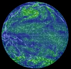 Earth: A Global Wind Map Quoting
Daily
Kos: " ... a new graphical development called the Earth Wind Map has
set a new standard for combining fascinating imagery with (near) real-time wind
information. Check it out and we think you'll agree that the 'wow' factor is
off the chart...
Earth: A Global Wind Map Quoting
Daily
Kos: " ... a new graphical development called the Earth Wind Map has
set a new standard for combining fascinating imagery with (near) real-time wind
information. Check it out and we think you'll agree that the 'wow' factor is
off the chart...
...the interactive map allows users to monitor wind patterns virtually anywhere on earth. The Google Earth-style display lets you adjust the globe's image to pinpoint any spot on the planet. Data is updated every three hours.
While flow patterns indicate wind direction — almost hypnotically — all over the planet, a subtle color scheme indicates wind strength, with gentle breezes represented by thin green lines, stronger winds by bright yellow, and extreme winds by red."
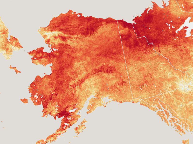
The
Effects of Global Warming in Alaska
In this media-rich lesson, students learn how global warming
is changing the Alaskan environment and examine the
consequences of climate change on the region's human and
wildlife inhabitants.
Lesson Plan Grades: 6-13+
Collection: Alaska Native Perspectives on Earth and Climate
![]()
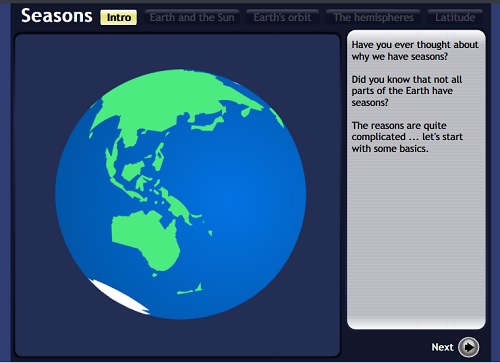
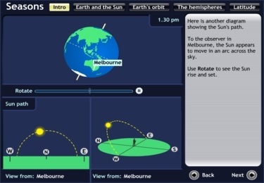
Seasons
This great Australian site is one small part of a bigger
internet education complex called Scootle.
Seasons
is designed to teach middle schoolers and up about the
interactions among orbits, axis tilt, rotations, and sunlight.
Students manipulate orbits, tilt, rotations, daylight, etc. to make
seasons.
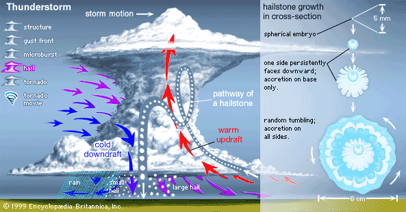
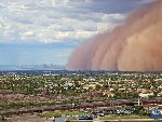 Haboobs,
or giant windy sandstorms.
Haboobs,
or giant windy sandstorms.
These monsters happen worldwide in
desert areas. The American Southwest
gets quite a few. Yes, "haboob" is an
Arabic word - like "coffee", "sofa",
"algebra", "apricot", "alcohol", "average",
"borax",
"Aldebaran" ( the star), "alligator", "candy",
"chemistry",
"sugar", "tuna", "zero", and many more.
Here are some sites with more information:
JetStream - An Online School for Weather
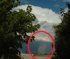
Here's a Wikipedia photo
of a hail shaft!
It's the white column coming down from the storm cell.
Get caught under one of these and there'll be hail to pay!
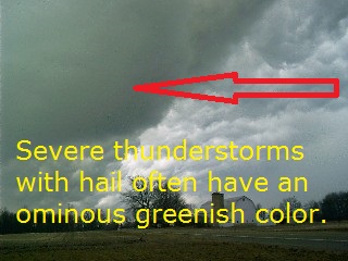
Here's a Wikipedia photo of storm clouds showing
the infamous greenish
color that means there is hail inside.
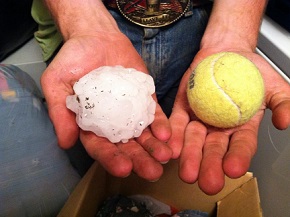
Click the link for a bigger
photo of this world record hailstone.
 and weight (1 pound 15 ounces). (NWS via Wikipedia)")
How Does Hail Form? Scientist explains how on this YouTube video.
Examine an animation of hail forming. From ClassZone.
Hail stones photo from Science Kids, a New Zealand site that's world class.
Giant Hail
Breaking Windshield (June 10, 2010 Last Chance, Colorado)
is the title of this YouTube video. Four minutes of guys driving while
hailstones smash their car! For sure this will bring home what it's like
to be in an extreme hail storm.
Yes there really is (or was) a Last
Chance, Colorado.
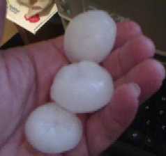
Here are two graphics and another photo:

Hermosa, South Dakota, June 2015
Below: These are also from South Dakota, along
the edge of the Black Hills. These dented cars,
broke windows, and ripped leaves from trees.
These stones had concentric white layers with
light blue centers.
Remember, if you see a big, very dark cloud
with green sections in it, take cover.
We hope you've enjoyed getting "hail-smart"!
Hurricanes,
Typhoons & Cyclones All about these extreme
storms. Animated guides explain hurricanes, typhoons, and
tornadoes, with lots more information to read.
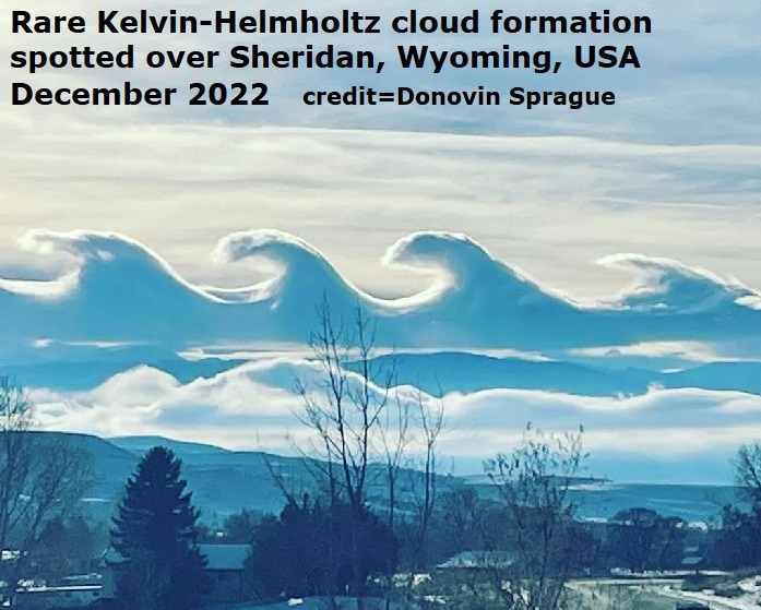
Kelvin-Helmholtz
clouds
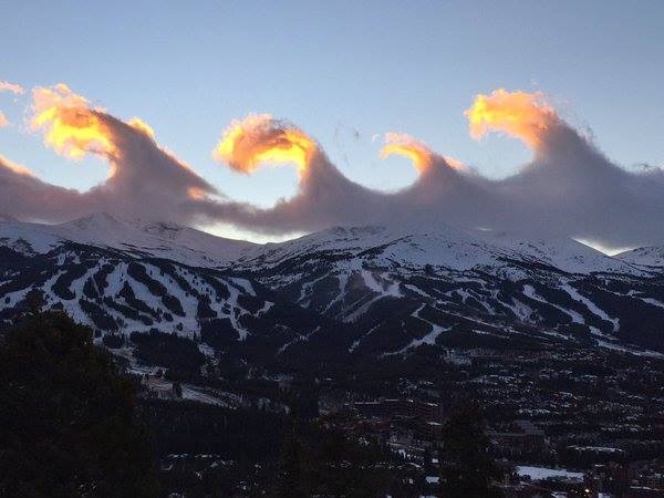
Hover over the photo to learn more.
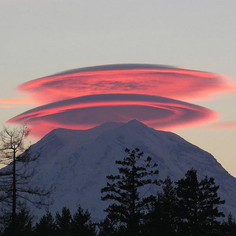
Lenticular clouds over Mt. Rainier. Click on the photo to learn more.
Lightning
Who else but WGBH in Boston would have a great
nine minute video about lightning, with links and teacher help, too?
NOAA Tracks storms, hurricanes,
typhoons, earthquakes
- a huge site with many links. Track hurricanes by clicking
on the NOAA Storm Tracker on the left of the page.
The Storm Tracker has a popup with various maps and data.
National Hurricane Center NOAA's central
site for tracking
hurricanes, typhoons, and tropical cyclones, worldwide
. All three are types of huge, ocean-going wind storms.
They have different names in different sections of the globe.
The start page shows Atlantic tropical storms and hurricanes.
This site has many sections, and it also links to other
weather sites. Use it properly and learn an awful lot
about these big and dangerous storms.
National Weather
Service Enhanced Radar Image Loop
National Mosaic Watch thunderstorms, blizzards, and other
weather move across America in nearly real time! Click on
any area that interests you to see a closer look at local weather.
![]()
National Weather Service Safety Tips
NWS has information about all sorts of disaster prep scenarios
and how to respond to them, divided into 19 categories.
![]()
Inspired by current local weather conditions,
we present this expandible
Wind Chill Chart!

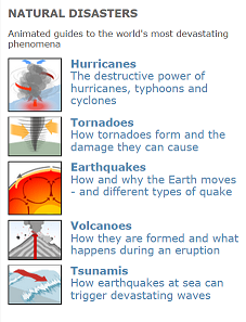
Natural Disasters "Animated guides to the world's most devastating
phenomena."
Five interactive gifs explain the basics of "how stuff works" with
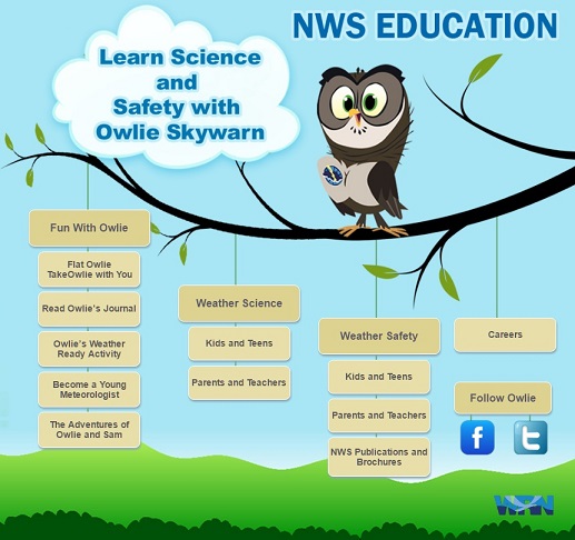
Kids will have a ball learning about weather with Owlie!
Look at the page below, lots of choices and topics!
Riding the Winds with Kalani - A Weather Adventure Weather for Primary Grades. This very colorful set of pages from U of I's Urban Extension covers the sun, seasons, temperature, types of clouds, and types of precipitation. Colorful, animated, and narrated, the site makes it easy for younger students to "get" these concepts.
Science News for Students is for ages 10 and up. Very interesting and NOT dumbed-down sections on: Atoms and Forces, Earth and Sky, Humans and Health, Life, Tech and Math, and Extra. Factual articles cover subjects in depth (examples: Electronic Skin, Cars of the Future, Caecilians - the other amphibian, Anesthesia MRIs, the Little Ice Age, Seabird Math, No Frostbite for Dogs, Life Beyond Earth. Plenty of graphics to grab interest.
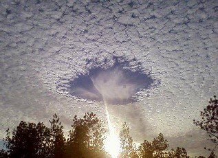 Skypunch More properly
called a "fallstreak hole"
Skypunch More properly
called a "fallstreak hole"
This is only a natural meteorological phenomenon.
This happens all over the world.
Ice crystals form above the high-altitude cirro-cumulo-stratus
clouds,
then fall downward, punching a hole in the cloud cover.
When some people see these, they think it's the end of the world.
They have thinking that since prehistoric times.
It is not a secret government conspiracy. It's just that some people are easily entertained and want to believe.
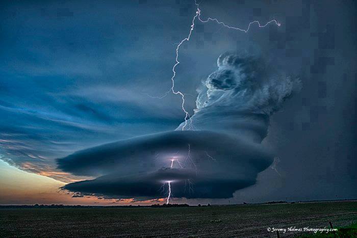
Supercells are the most severe classification of thunderstorms. Even though it is the rarest of storm types, the supercell is the most dangerous because of the extreme weather generated.
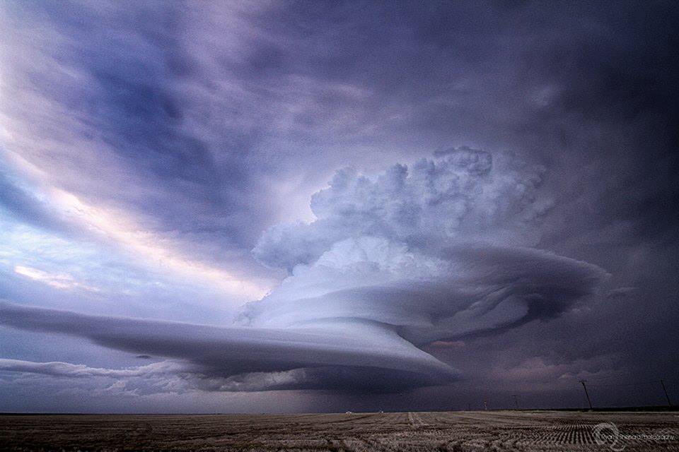
Credits: Science Is Awesome on Faceboook.
Top photo: Ryan Shepard, Greeley, CO,
or check him out on ![]()
Lower photo: Jeremy Holmes Photography It's NOT a painting, it's a photo!
Credit: University of Illinois
Wikipedia
has an excellent description, and
beautiful, scary graphics.
“A
beast”: Shocking, enlightening supercell
thunderstorm photos from Nebraska.
These are pretty much definitive!
A Supercell
Thunderstorm Over Texas This is
the famous Mike Olbinski video! It
is scary. A
great and valuable video record of one of these
things in action.
Here's a Mike Oblinski photo
of an eerie green and
purple storm with mammatus clouds.
Jaw-dropping
Photographs Capture the Sublime
Power of Superstorms These photographs say it all
(and have descriptions). If you live somewhere these
monsters never pass through, be glad.
From Robert T. Gonzalez on IO9.
Storm
of June 16, 2015 by Michaela Mader from
the Black Hills FB page, which does photo contests
of the area.
Scary, stunning, beautiful, horrible, awesome, and
awful. To really bring this monster home, click on
this thumbnail to see a much larger copy!
The Thermohaline Circulation - The Great Ocean Conveyor Belt, from NASA. Watch as the warm water of the Gulf Stream flows north to the Arctic. The warm water is the reason Europe is not frozen solid, like northern Canada. Watch as the water comes up to Greenland and Iceland; and then sink down and get colder, denser, and saltier. Then the now-cold current heads south along the ocean floor. After it flows around the world, it picks up heat, rises and then flows back north. This video explains it very simply and in 3D!
Please give credit for this item to:
NASA/Goddard Space Flight Center Scientific Visualization Studio The Blue Marble
Next Generation data is courtesy of Reto Stockli (NASA/GSFC) and NASA's Earth
Observatory. The Blue Marble data is courtesy of Reto Stockli (NASA/GSFC).
Time-Lapse: Mesmerizing "Stormscapes" Dominate Skies This 2:59 video of an extra-large and nasty supercell system was shot during the summer of 2013 in extreme eastern Wyoming. This was just off the western edge of the Black Hills, between Newcastle and Wright. "The menacing, magnificent storm clouds of Wyoming come to swirling life in this time-lapse, "Stormscapes," by photographer Nicolaus Wegner. He braved lightning and the erratic fury of supercell storms to capture these images in the summer of 2013." Video credits are at the end, please watch them.
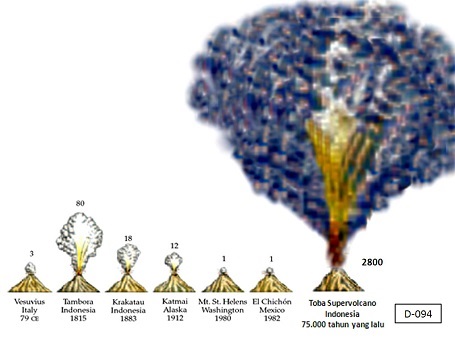
Problem Solving Activity: Volcanoes and Climate Change
The Weather Channel Kids! Local forecasts, weather for trips, on your desktop, a Dictionary, a Glossary, a resource guide, teacher resources, weather games (in progress), more.
Web Weather for Kids Old and respected kids weather site covers clouds, blizzards, hurricanes, tornadoes, thunderstorms with games, activities, lots of good information and many links to more "stuff."
Weather Infographics from Weather Underground "Welcome to Weather Underground's infographics library. Browse these engaging infographics to discover the science behind weather in a simple and fun way." Sixteen engaging infographics explain phenomena like, "Why is the Sky Blue?", sundogs, volcano types, earthquakes, rainbows, hurricanes, floods, droughts, monsoons, and more.
Weather Questions This page answers your weather questions! It's in alphabetical order, and answers everything from "What are Aerosols?" to "What is Wind Shear?" Easy to read and accurate answers.
Weather Wiz Kids A site from a working television meteorologist. "I designed this website especially for kids to allow them to learn more about the fascinating world of weather. It’s also a wonderful educational website for teachers and parents that gives them the right tools they need to explain the different types of weather to children. " Huge menu on the left side of the home page has tons of weather and geology-related links.
Wind Chill Calculator
from NWS. Enter a temperature
in degrees C or F. Enter the wind speed in mph,
kph, knots, or meters/second. Click Convert and you're
done. Results are given in Fahrenheit, Celsius, and
in Watts per meter squared. The site also has the
formula used to do the conversion, with tips on what
to change to get more exotic results.
Wind Chill Chart
to check your work or for quick
reference. There is a box to right of the chart that
lists other winter weather resources.
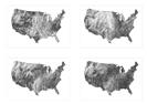 wind map "An invisible, ancient source
of
wind map "An invisible, ancient source
of
energy surrounds us—energy that powered
the first explorations of the world, and that
may be a key to the future. This map shows
you the delicate tracery of wind flowing over the US."
Fantastic art accurately reflects current winds!
![]() to top of page
to top of page ![]()
![]() to Good Sites!
to Good Sites! ![]()
![]() to Science and
Nature
to Science and
Nature
Powered
by ![]() The World's #1 Web Host
The World's #1 Web Host
![]()